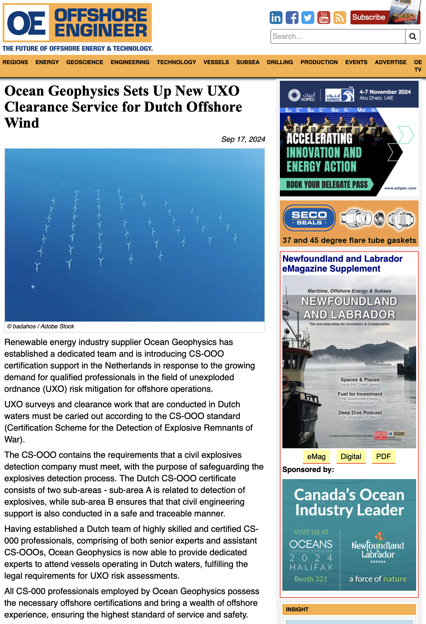
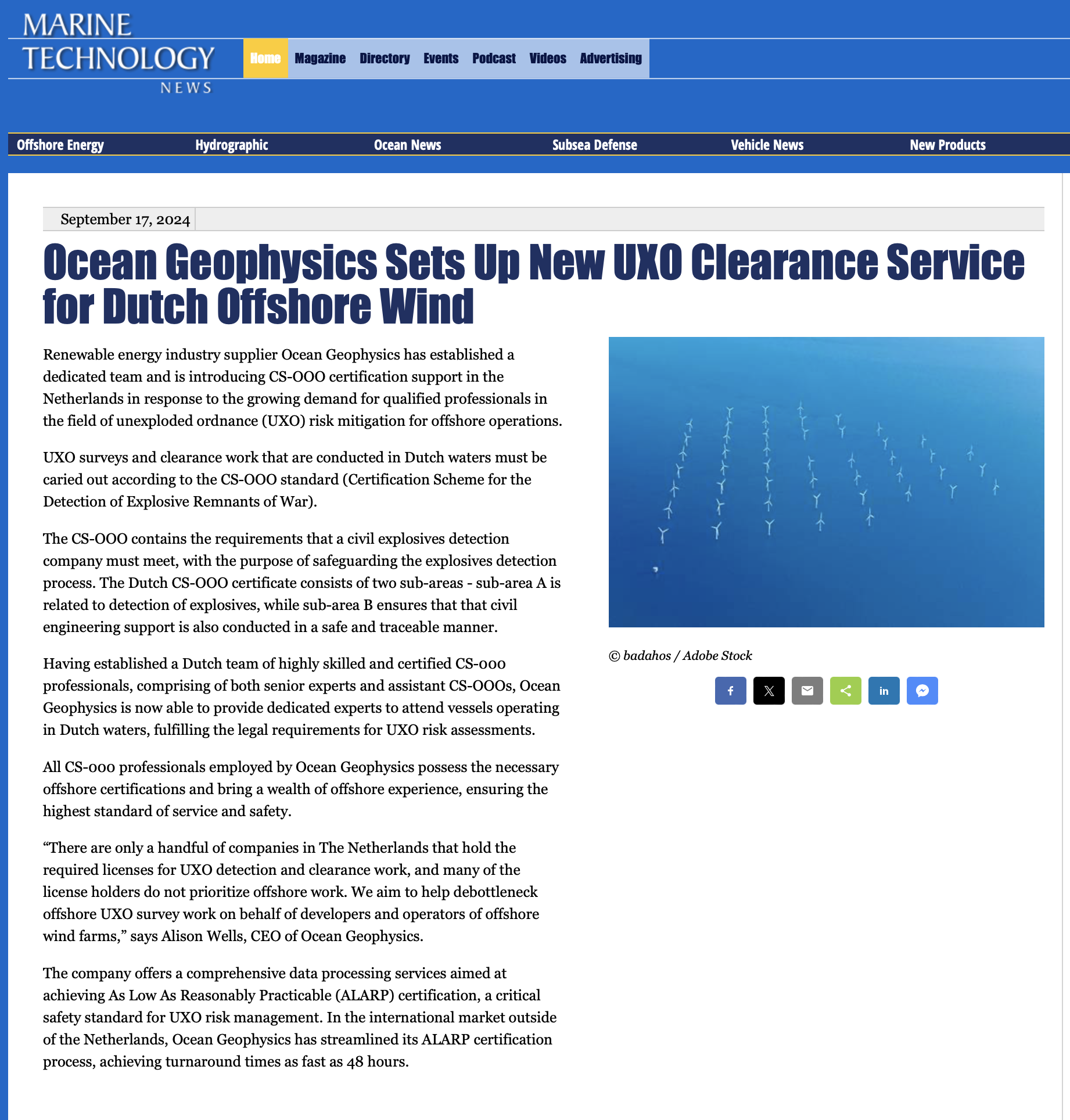
Offshore Engineer – Ocean Geophysics Sets Up New UXO Clearance Service for Dutch Offshore Wind
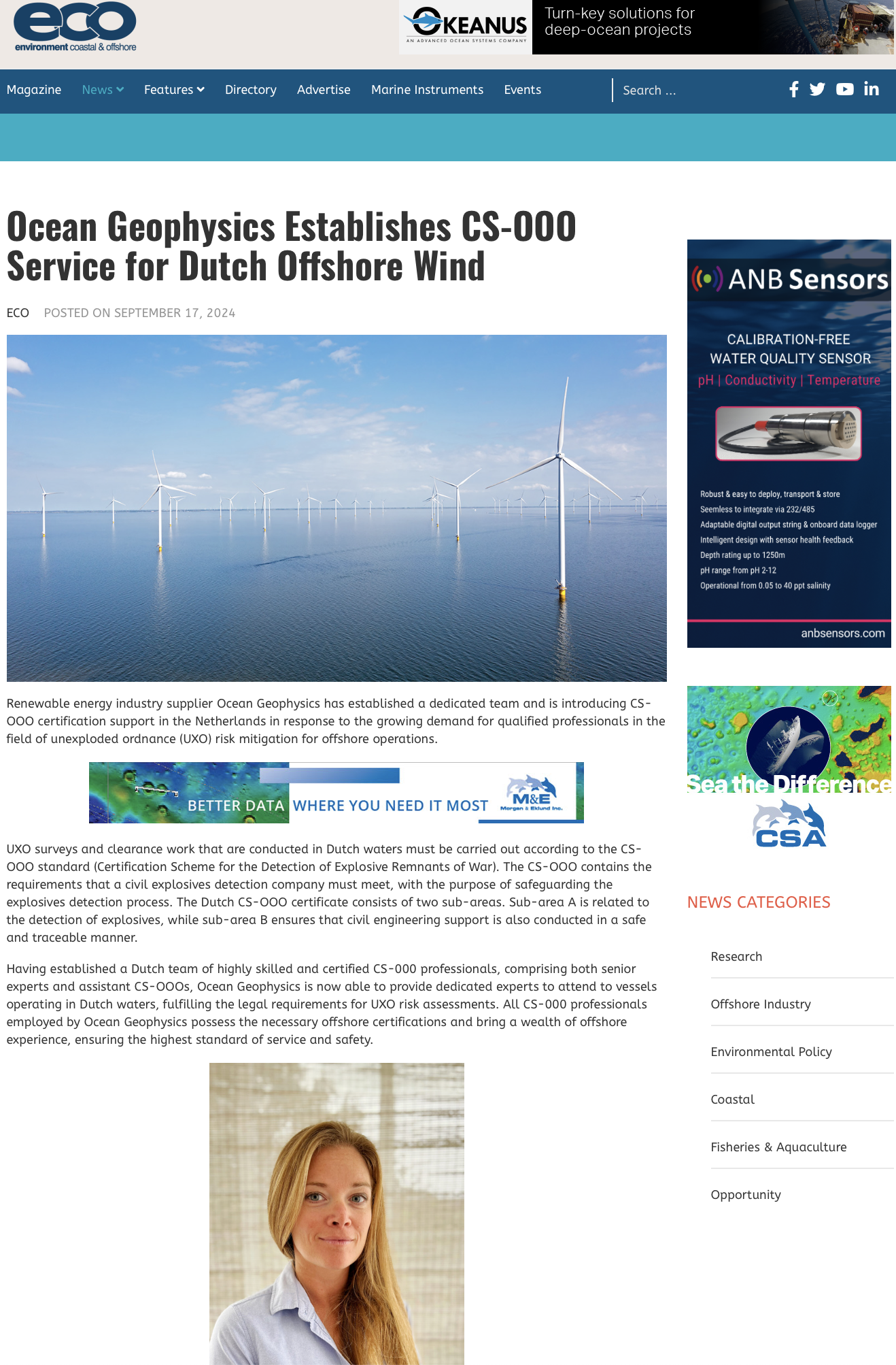
Sep 17, 2024 Renewable energy industry supplier Ocean Geophysics has established a dedicated team and is introducing CS-OOO certification support
At Ocean Geophysics, our mission is clear and resolute: We exist to become the global benchmark in geophysical data processing excellence.
Guided by our founders’ visionary ambition, we are dedicated to providing unmatched solutions that empower our clients to unlock the full potential of their geophysical data.
We hold fast to the belief that every day is an opportunity to learn, teach and improve, which is why we commit ourselves to the continuous up-skilling of our entire team.
Our unwavering commitment to fostering a joyful work environment underscores our belief that a happy team is a productive one. We strive to create a space where every team member thrives while prioritising their well-being.
Our dedication to being the best data processors drives us to continually push the boundaries, develop cutting-edge technologies, and elevate the industry standard.
We pride ourselves on our unparalleled commitment to data delivery, ensuring that our clients can consistently amaze their own clientele with the most remarkable versions of each data set.
As Ocean Geophysics, we are your partners in achieving geophysical data excellence and helping you dazzle the world with the extraordinary potential of your data.
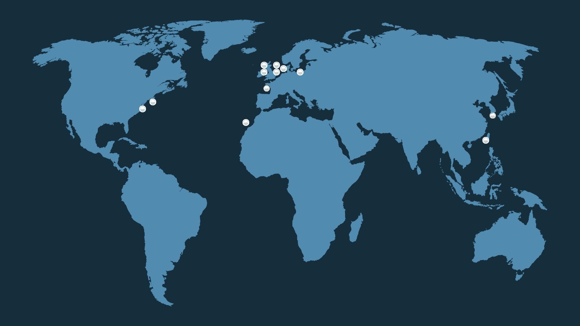
Ocean Geophysics was founded on the audacious vision of becoming the world’s premier geophysical data processing company. From day one, our mission has been straightforward: if you’re not proceeding with your data in-house, Ocean Geophysics is the team doing it for you.
Our philosophy revolves around embracing each day as an opportunity for growth and learning.
We actively invest in the continued development of all our team members, regardless of their role.
We believe that a happy workplace is a productive one.
We work diligently to create an environment where everyone can thrive while focusing on their well-being. Moreover, our commitment to being the best data processors is unwavering.
We constantly challenge ourselves to push bounties and innovate, harnessing the latest technologies to elevate our client’s data to its fullest potential. Our dedication to data delivery knows no equal.
We take immense pride in enabling our clients to astound their own clientele with the most exceptional versions of each data set. Our vision is to empower you to amaze, and we will stop at nothing to achieve it.
Alison has a proven track record of business start-ups and development. She previously held managerial positions across the hospitality sector, architectural practices and luxury goods manufacturers with an international multimillion-dollar turnover.
Alison now holds the position of Chief Executive Officer. Prior to joining Ocean Geophysics, Alison was employed as the UK office manager and CEO assistant for Aqualis Offshore, bringing with her established family links to ABL group.
John is an experienced oil and gas executive with a background in petroleum engineering. He joined Shell from university and then moved to BG where he undertook several senior roles including Director of International Development and VP for Kazakhstan. After BG John served as a board director in both executive and non-executive roles in Bowleven Plc and RockRose Plc. he retired from Glencore as Head of Oil and Gas E&P in 2019.
John now undertakes Board advisory work and is a non-executive Director (Harbour Commissioner) at Lymington Harbour, a UK Trust port.
Robert has over 18 years in terrestrial, marine and airborne geophysical projects; covering mobilisation, acquisition, processing, interpretation and reporting. Highly experienced in data survey management and survey design. Notable projects include KERP UXO project (Kuwait Environmental Remediation), Nordstream, EAOW1, London Array and Formosa.
Robert graduated from the University of Southampton with an MSci in Geophysics and an MSc in Coastal Engineering. Having fostered a great passion for GIS optimisation and magnetic field survey, Robert is a published Geophysicist, with the white paper: UXO characterisation by 3D seismic constrained magnetometry inversion. Robert most recently presented at Oceanology 2022 delivering a keynote speech on Magnetic target prioritisation
Eric is a highly regarded Geophysicist. Joining Ocean Geophysics from contracting for Ocean Infinity, having been the team lead for geophysical processing on the Beacon Wind project (New York). As Director of Data Processing, Eric brings his experience in the acquisition, processing and interpretation of a wide range of geophysical data including Single and Multi-Channel Seismic, Magnetic total field and Gradiometer, Gravity and Resistivity, Side Scan Sonar and Sub Bottom Profiler. Previous notable projects include Aquind interconnector, Nordlink and Guanyin offshore wind farm (Taiwan).
Eric has an MSci in Geophysics from the University of Southampton and is fluent in French.
A seasoned professional with extensive offshore expertise and a profound understanding of marine surveys. His career, primarily in challenging marine environments, spans data acquisition and analogue geophysical dataset processing, with a specialised focus on interpreting magnetic and electromagnetic data for UXO detection.
David’s geophysics journey began after obtaining his MSc in Geology from Ohio University, where he contributed to the Kuwait Environmental Remediation Project as a UXO Geophysicist, honing his skills in processing time-domain electromagnetics. Over the years, he has undertaken diverse survey projects for prestigious clients such as Google, Equinor, Vineyard Wind, Empire Wind, and General Communication Inc. Despite encountering data of varying quality, David remains steadfast in extracting valuable insights from each survey, ensuring clients comprehensively understand their exploration sites. His unwavering dedication to delivering high-quality, actionable insights cements his role as an invaluable asset to our team and a trusted partner for our clients’ geophysical needs.
Over the past 14 years, Chris has excelled in geophysics with a specialisation in UHR seismic processing, establishing himself as a recognised industry professional. His journey began at Southampton University, where he gained a solid educational foundation in shallow marine geophysics principles and techniques. Chris’s practical experience spans projects involving MBES, SBP, MAG, and UHR seismic applications, where he’s honed his skills.
As a UHR geophysicist, Chris has led teams in acquiring, processing, and interpreting seismic data for projects demanding the highest resolution and accuracy. He’s adept at utilising advanced algorithms to uncover fine-scale details, identifying critical subsurface features such as thin-bedded reservoirs, fractures, and fault zones. Collaborating with multidisciplinary teams, he integrates seismic data into comprehensive geological models, optimising exploration strategies and enhancing reservoir characterisation.
Chris’s analytical prowess extends to troubleshooting anomalies, refining processing workflows, and implementing quality control measures. He remains at the forefront of industry advancements, participating in conferences, workshops, and recent research as a co-author focused on deghosting. His dedication and expertise have earned him a prominent role in the geophysics community, significantly impacting exploration, production, and the field’s ongoing development.
Thomas is an experienced hydrographic processor with a well-rounded background in both online data acquisition and offline data processing.
Throughout his career, Thomas has undertaken diverse range of hydrographic and geophysical projects, primarily involving UXO and offshore wind farm operations, as well as projects for the UK and Dutch hydrographic authorities.
Thomas has a BSc in Hydrography from the University of Plymouth and is accredited with meeting the standards of competence for Hydrographic Surveyors and Nautical Cartographers prescribed for Category A by the board of the International Hydrographic Organisation (FIG/IHO/ICA Cat A).

Nicholas is a data processing expert, supporting Ocean Geophysics to respond to the challenges presented by big geophysical data. Nicholas obtained his PhD in experimental physics from Durham University and began a career in experimental quantum computing.
Nicholas’ research concerns the isolation and characterisation of the most delicate and fundamental phenomena: quantum correlations between individual atomic particles. Nicholas has extensive experience solving challenging physical problems, interfacing lab equipment, analysing enormous datasets, and producing beautiful reports.
Within Ocean Geophysics, Nicholas leads research and development. Nicholas works responsively to eliminate roadblocks from Ocean Geophysics’ data processing pipelines, ensuring Ocean Geophysics can consistently deliver on time. Nicholas also maintains a core set of resilient, automated systems that support Ocean Geophysics’ ability to provide high-quality, assured outputs faster than the competition, often at the push of a button.
With 16 years of experience in marine and land geophysics, Anthony has worked most recently as the senior geophysicist for MMA Offshore Australia. Prior to this he specialised as a UXO survey consultant on a variety of projects in oil and gas, construction and renewables from locations in Europe, the Middle East, Central and South East Asia. Previous clients include MMT, N-Sea, Tennet Germany, RPS Energy, Kuwaiti Oil Company (KOC) and Formosa.
Anthony has a masters degree in Geophysicis from the University of Southampton. When he’s not processing geophysical data you can find him practising his crosswind landings at his local airfield in Perth, Western Australia.
Ines holds a master’s degree in Marine Geosciences from the University of Bremen, Germany, and possesses a degree in Remote Sensing from the University of Tasmania.
Her passion for exploration has led her to participate in research cruises to remote and challenging locations, including expeditions to Antarctica, where she has played a pivotal role as an integral part of the multibeam processing group. In this capacity, she was further responsible for 3D photogrammetric modelling of deep-sea geology.
Ines has presented her research at prestigious conferences, including the Geohab Conference, and has contributed to the creation of multiple published datasets related to multibeam and backscatter data. Her diverse experience also includes work as a hydrographic surveyor, where she has acquired multibeam, sidescan, and magnetometer data.
Currently, Ines is actively engaged in research and is working on a paper centred on Python-based Satellite-Derived Bathymetry in addition to her current responsibilities.

Kai is a dynamic professional with a business development and geophysics background, showcasing a proven track record during his role as Business Development Administration Manager at DUG. His expertise spans sales support, proposal preparation, and effective communication with both internal and external stakeholders. Kai’s proficiency in data analysis, reporting, and cross-functional collaboration has been instrumental in fostering data-driven decision-making.
His diverse professional journey includes roles as a Geophysicist at CGG and DUG, as well as a Field Service Engineer. Holding a Master’s Degree in Petroleum Engineering and Geosciences from Delft University of Technology and a Bachelor’s Degree in Mechatronics Engineering, Kai is characterized by his commitment to continuous learning, critical thinking, and impactful communication. Eager to take on new challenges, he brings a wealth of experience and a proactive professional approach to every endeavour.
Chadaporn (Ob) began working for the Department of Groundwater Resources (Thailand) after receiving a Bachelor’s in Geology from Chulalongkorn University. She was given the outstanding opportunity to attend graduate school in the USA after being granted a highly competitive scholarship by the Thai Government. She completed a master’s degree in Geological Sciences at Ohio University.
Upon returning to Thailand, Chadaporn continued to work for the Department of Groundwater Resources, this time as a professional-level geologist. Primary duties consisted of leading field resistivity surveys and borehole studies to promote the availability of clean water for some of the most remote Thai communities. Her strong background in electrical resistivity made the transition to marine geophysics a smooth one. As a marine geophysicist, Chadaporn now specializes in the processing and interpreting sidescan sonar and sub-bottom profiler data sets alongside report writing.

Thomas brings a diverse technical background and extensive experience in software engineering, AI solutions, and full-stack development.
With nine years of experience, his expertise in Python, JavaScript, React, and modern software technologies will be invaluable as we enhance our seabed data analysis capabilities.
Thomas has worked globally, contributing to diverse projects, from supply chain solutions to digital business development. Notably, he has collaborated with Fortune 500 companies like CH Robinson and Microsoft, where he addressed technical challenges and optimised business processes.
His ability to translate complex technical requirements into efficient, user-friendly applications will drive our mission forward. His strong communication skills and experience in working with diverse, global teams enable him to collaborate effectively with stakeholders at all levels.

Susan is a creative and compassionate software engineer with over 15 years of experience delivering versatile, scalable software solutions. By way of individual technical contributions, exceptional team management, and adapting to the business needs of both small startups and large international NGOs, her experience has generated impact across sectors ranging from agriculture, education, healthcare, and social enterprise in both North America and Sub-Saharan Africa.
Susan graduated from the University of Delaware Honors Program with a double major in Computer Science and Psychology and a minor in Cognitive Science. She is excited to work with a rapidly growing team, developing simple yet sophisticated, human-centred technology and bringing mission-critical, transformative applications to life at Ocean Geophysics in Northern Thailand.
Mark is a leading industry UXO specialist. His extensive experience in overseeing UXO-related projects ranges from survey and identification to the clearance operations of dumped munitions in both the terrestrial and marine field bolsters.
His long track record includes the successful management of domestic and international infrastructure and construction projects, including wind farms, cable routes, experimental carbon capture and oil and gas throughout Europe and the Americas.
In addition to this Mark is a certified ROV pilot with over ten years of experience.

Neil McLoughlin is a survey Geophysicist and engineer with broad survey experience in the oil and gas, cable laying, wind farm and UXO industries. Mobilising, acquiring and delivering Geophysical data for a wide variety of clients successfully including: Orsted, SPR, NPD, Total energy, EDF, INEOS, Shell, ENI and Vattenfall. Neil is driven by the delivery of high-quality data and processing to clients through a dynamic and cooperative team.
Neil has a Bachelors degree from Southampton and has published a paper as well as contributing and processing data to contribute the research of deep-sea tomography of continental oceanic margins. Neil is a scanfish engineer as well as a Geophysicist and has completed many SIT/EVTs leading previously unexperienced teams offshore to successful UXO verifications.

Ramon is an accomplished English Second Language Trainer with over 25 years’ experience. He specialises in tailored English lessons for ESL learners, emphasizing integration of language skills with professional contexts, particularly in work environments. Ramon’s diverse career includes 7 years on a Copper mine (in Laos) and the past 25 years in Thailand, during which he delivered impactful professional development sessions for local staff, enhancing language proficiency within communities.
Proficient in Thai and Laos, Ramon enriches his teaching with cultural sensitivity, creating an inclusive and effective learning environment for learners of diverse backgrounds, reflecting his passion for empowering students with essential language skills in the workplace.
With over 14 years of experience in oil & gas and telecommunication, Lugkana Chutkaew (Nuna) has worked for companies such as Chevron Thailand and EGS Asia. She has an extensive background in geology and geotechnical, as well as experience with a variety of software applications and scientific instruments. Highly skilled in 2D & 3D seismic and Sidescan data acquisition, processing and interpretation. While working with Chevron, she was involved with geophysical interpretation and reporting for platform site surveys, pipeline route / as-built surveys and jack-up rig emplacement surveys.
Nuna has been instrumental in identifying potential proposed platform locations, site investigations for offshore installations, inspection of existing seabed foundations, geohazard assessments for offshore drilling operations.
She has had the opportunity to work with EGS Asia as a marine geophysicist for cable route surveys in 2022-2024 and delivered geophysical data (MBES / SSS / MAG / SBP data processing) for a wide variety of clients including SubCom LLC, Trans Americas Fiber Limited, HMN Technologies and Alcatel submarine network (ASN).
Nuna has always been committed to professional growth. Her proactive approach to problem-solving, combined with my ability to adapt to new technologies and methodologies, has consistently resulted in increased efficiency and accuracy in data interpretation.

Jonathan is an accomplished geophysicist with over nine years of experience in nearshore and offshore surveys, specializing in UXO and magnetometry within the offshore renewables sector. Throughout his career, he has gained extensive knowledge of various geophysical datasets, from mobilization to the reporting phase. He has played a significant role in offshore wind and site characterization surveys across the UK and Europe, working with major clients such as Orsted, Equinor, RWE, and Vattenfall.
Jonathan excels in leading geophysical data quality control, managing processing teams, and mentoring junior staff, drawing on his extensive offshore experience. He holds an MGeol in Geology and has a passion for volcanology, further enriched by his history of travel and research. His research includes volcanic studies in Mexico and Italy, and he has presented his findings at the BCUR. Additionally, he received the Roland Levinsky Memorial Fund from the University of Plymouth to support his research endeavors.

With over a decade of experience in supply chain operations, business analytics, and operational finance, Tom has played pivotal roles at leading blue-chip companies like General Electric and Danaher in their life sciences divisions.
Tom is recognised for his collaborative leadership style and his ability to thrive in team settings. Tom brings a strong aptitude for solving complex problems and excels in fostering effective communication and building relationships, which have been key to achieving successful project outcomes.
Offshore Engineer – Ocean Geophysics Sets Up New UXO Clearance Service for Dutch Offshore Wind
Sep 17, 2024 Renewable energy industry supplier Ocean Geophysics has established a dedicated team and is introducing CS-OOO certification support
Marine Technology News – Ocean Geophysics Sets Up New UXO Clearance Service for Dutch Offshore Wind
SEPTEMBER 17, 2024 Renewable energy industry supplier Ocean Geophysics has established a dedicated team and is introducing CS-OOO certification support
ECO Magazine – Ocean Geophysics Establishes CS-OOO Service for Dutch Offshore Wind
ECOPOSTED ON SEPTEMBER 17, 2024 Renewable energy industry supplier Ocean Geophysics has established a dedicated team and is introducing CS-OOO